


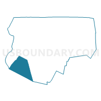
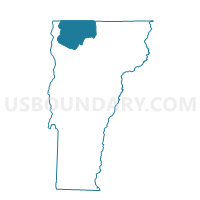
Georgia Voting District, Franklin County, Vermont
About
Outline

Summary
| Unique Area Identifier | 680811 |
| Name | Georgia Voting District |
| County | Franklin County |
| State | Vermont |
| Area (square miles) | 45.22 |
| Land Area (square miles) | 39.33 |
| Water Area (square miles) | 5.89 |
| % of Land Area | 86.97 |
| % of Water Area | 13.03 |
| Latitude of the Internal Point | 44.72243850 |
| Longtitude of the Internal Point | -73.12845190 |
Maps

Graphs
Select a template below for downloading or customizing gragh for Georgia Voting District, Franklin County, Vermont


Neighbors
Neighoring Voting District (by Name) Neighboring Voting District on the Map
- Fairfax Voting District, Franklin County, VT
- Fairfield Voting District, Franklin County, VT
- Grand Isle Voting District, Grand Isle County, VT
- Milton District 1, Chittenden County, VT
- Milton District 2, Chittenden County, VT
- St. Albans Voting District, Franklin County, VT
- Westford Voting District, Chittenden County, VT
Top 10 Neighboring County Subdivision (by Population) Neighboring County Subdivision on the Map
- Milton town, Chittenden County, VT (10,352)
- St. Albans town, Franklin County, VT (5,999)
- Georgia town, Franklin County, VT (4,515)
- Fairfax town, Franklin County, VT (4,285)
- Grand Isle town, Grand Isle County, VT (2,067)
- Westford town, Chittenden County, VT (2,029)
- Fairfield town, Franklin County, VT (1,891)
Top 10 Neighboring Elementary School District (by Population) Neighboring Elementary School District on the Map
- St. Albans Town School District, VT (5,999)
- Georgia School District, VT (4,515)
- Grand Isle School District, VT (2,067)
- Westford School District, VT (2,029)
- Fairfield School District, VT (1,891)
Top 10 Neighboring Secondary School District (by Population) Neighboring Secondary School District on the Map
Top 10 Neighboring Unified School District (by Population) Neighboring Unified School District on the Map
Top 10 Neighboring State Legislative District Lower Chamber (by Population) Neighboring State Legislative District Lower Chamber on the Map
- Franklin-2 State House District, VT (9,167)
- Chittenden-9 State House District, VT (9,039)
- Franklin-1 State House District, VT (8,800)
- Grand Isle-Chittenden-1 State House District, VT (8,283)
- Chittenden-6-3 State House District, VT (4,331)
Top 10 Neighboring State Legislative District Upper Chamber (by Population) Neighboring State Legislative District Upper Chamber on the Map
- Chittenden State Senate District, VT (139,478)
- Franklin State Senate District, VT (46,235)
- Grand Isle State Senate District, VT (22,039)
Top 10 Neighboring 111th Congressional District (by Population) Neighboring 111th Congressional District on the Map
Top 10 Neighboring Census Tract (by Population) Neighboring Census Tract on the Map
- Census Tract 21.02, Chittenden County, VT (7,529)
- Census Tract 29, Chittenden County, VT (6,227)
- Census Tract 106, Franklin County, VT (5,999)
- Census Tract 110, Franklin County, VT (5,562)
- Census Tract 109, Franklin County, VT (4,515)
- Census Tract 202, Grand Isle County, VT (3,698)
- Census Tract 104, Franklin County, VT (3,213)
- Census Tract 21.01, Chittenden County, VT (2,823)